
Here we are in the famously gridded city of Philadelphia, in the 1830s, when Frances Trollope and Tyrone Power reported that the city was easy to navigate. As Power said, “the stranger’s course [is] an exceedingly easy one” (Impressions of America, During the Years 1833, 1834, and 1835 [1836], 1:81). But there in the Public Ledger of July 25, 1836, is an anonymous rant claiming that it is impossible to find one’s way around Philadelphia, even for elderly Friends who have lived here all their lives. Navigation Continued: “Marks and Numbers of Streets,” from the Philadelphia PUBLIC LEDGER, 1836
Is this really a contradiction? If we think about legibility, the patterning or reference system described by Kevin Lynch, we can say that Philadelphia was compact and regular, set out in the narrow waist between two rivers. Inhabitants should always have known where they stood in relation to the points of the compass, the rivers, and agreed-upon local landmarks.
The complaint in the Public Ledger was about legibility in a less sophisticated sense. The city was impossible to navigate, it was claimed, because of the regularity and similarity of the streets, which made blocks look alike (a point also made by Frances Trollope), and because there were scarcely any street signs, except for a few faded boards, possibly relics of Penn’s era. Streets could be found by counting squares on a map. The grid needed guide boards.
Could it be that the former national capital, the city of the Society of Friends and of Benjamin Franklin, was so lacking in civic common sense as to neglect street signage? And what about all the inset marble (or brownstone or metal) street signs, often paired at the corner, that survive on brick buildings in old neighborhoods? About 240 have survived demolition, stucco, and siding. About a quarter of those signs–prized among the prizes–are for street names that no longer exist (please see my Flickr album of signs). If those signs did not exist in 1836, when did they go up? And who was responsible for them?
Old images are full of street signs, but they appear incidentally. Marble, metal, or painted wood–it’s hard to tell, though signs that were affixed rather than inset tend to have shadows at the bottom. A search of old images found more than fifty vanished signs that were probably inset, and made of marble. About twenty of them are in pairs, usually meeting at the corner.
Those images can’t tell us when the signs went up. Records of street name changes provide the earliest possible dates for signs. The records also provide latest possible dates for former-name signs. It seems that, of the former street names, ten changed at dates yet unknown, five changed in 1858, and about thirty changed in 1897. Indeed, if you look at the Bromley atlas for 1910, you will find current names all over town. A few names turn up in maps after being changed by the city (e. g., Hull for Elkhart in the 1910 Bromley). The still-ubiquitous white on blue wall signs turn up in photos starting about 1900. Everyday incised signage seemed to wane with the century, though many buildings before and since have been designed with incised (or separate-letter) street signs to add gravitas to banks, electric stations, or self-conscious new housing.
Was the city responsible for the incised signs? Not according to Common Council records (available for ca. 1836-1919, with possible gaps, thanks to the HathiTrust). It is unlikely that the city, which had to change signs when the names changed, would have been scraping out and replacing incised signs. Our dozens of former-name survivors suggest that that was not done. We can’t know how many incised signs existed, or where they were, but enough old images show brick corner buildings without street signs, to suggest that they did not go up according to a plan. Besides, though almost all the signs are at stringcourse level, some are a story higher; some corners have paired signs and others only one. We find a both-ends, opposite-sides signage plan on a few blocks of surviving speculative housing: Silver (Bishop) and Seltzer (Coffman) between Thirteenth and Park; Darien above Somerset; Napa (Chalfont) between Spring Garden and Hamilton; and Wakefield (Fairfax) between E. Price and E. Rittenhouse. But developers of uniform blocks left hundreds of corner buildings without incised signs.
Then what did the city do about signage, and what types are mentioned in the records? Clearly, it was managing street signs by the late 1830s. (Perhaps the ranter of 1836 was an unsung hero, an instigator of signage reform.)
In Common Council records for the late 1830s, there are repeated references to the painting, putting up, repairing, and updating of street signs. The city also monitored damage to, and removal of, signs. Appropriations for these services were a regular part of the budget. At the end of the 1830s, the council considered plans that were carried out at the time of consolidation: numbering north-south streets from the Delaware to the Schuylkill, rather than numbering from both rivers toward the center; and adding directions N, S, E, and W “at the corners of all the Streets and Alleys” (street signs were no longer rare), “E” and “W” breaking at Broad, not, as we see now (for the most part), at Front.
With marble signs, we have little history, but plenty of examples. With municipal signage before 1900, we have lots of history, but few surviving examples. Several types of signs are mentioned, but the terminology seems vague, flexible, and changeable. Why define precisely what everyone sees every day?
The 1836 complaint speaks of old guide boards of the “shape, size and color of a weather beaten shingle.” City records from the 1830s to ca. 1900 speak of corner signs, painted and apparently wooden (they were made and maintained by a city carpenter), finger boards or fingerpoints, painted index boards, index plates (possibly metallic), and sign boards. The metallic signs might have been painted like the white on blue wall signs, or “typeset” from metal letters, like the ones that survive at Lemon and Tenth NW, Pine and Ninth SW, and Waverly and Sixteenth SE (with the former name, Stone). If we can trust image searches, it seems that guide boards (1836), direction boards (1837-39), index boards (city records, intermittently, 1838-80; but John Fanning Watson [Annals of Philadelphia. . . 2: 492] had noticed index boards ca. 1800), and finger boards (1839, 1840, 1841, 1854), might point away from themselves. Sign boards (1848, 1857-74, 1883-89, 1891-95, 1897-1912) may be the rectangular, non-pointing signs in old images, fastened to the wall (as a board would be), rather than inset. (Or they might be marble insets.) A survey of old images revealed about twenty that could show one or the other, with another thirty most likely sign boards.
In the midst of these ambiguous and overlapping designations, two old signage styles stand out.
The first to appear was the fingerpoint or finger board, a wall sign (also seen in clusters on a pole, at highway intersections) with a pointing hand at one end, like the manicule in the margin of an old manuscript (or pointing up or down on a tombstone). I have found about 48 fingerpoint signs in old Philadelphia images.
https://digital.librarycompany.org/islandora/object/digitool:67925
https://digital.librarycompany.org/islandora/object/digitool:35925
https://digital.librarycompany.org/islandora/object/digitool:65515
https://digital.librarycompany.org/islandora/object/digitool:65655
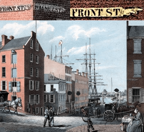
They are charming, but puzzling. Pointing signs usually direct attention away from their location, but the decipherable fingerpoint signs seem to be on the streets they name. “FRONT ST.” on the Front Street side of a building is a label, not a pointer. Then what does the pointing mean? The orientation is not toward the corner; some point away from the corner. Perhaps they regulated traffic? I found three Chestnut Street fingerpoints, all pointing east, but that could be coincidence. And why have traffic regulation on Plynlimmon Place, a dead end narrower than nearby Elfreth’s Alley? In fact, one-way streets seem to have appeared here only in the twentieth century.
The second example of striking signage shows how sidewalk corners pick up public functions. As rowhouses acquired porches, bay windows, elaborate corbels, turrets, and abundant greenery, wall signs persisted, but might have been hard to see. For other buildings, like houses of worship, they seem to have been considered inappropriate. So, while also taking into account the increasing speed of travel, sidewalk signage became attractive. In 1868, Thomas T. Markland Jr. patented a “new and useful Improvement in Street-Lamps and other lamps,” which he proposed for use in Philadelphia. His improvement was “street-lamps with name-plates in the main body of the lamps, but [attached to the frame and] separate and distinct from the large glass plates,” so the names would not be lost if the plates broke. Markland’s patent speaks of perforated letters, but the Common Council speaks of “block letter[s]” with spaces in between, as shown in the right-hand image below, and in other old images. There would be signs on all four sides, so that the street names could be seen from all directions. (By the way, note the contrast below between Fifth and Fifth and Chestnut and Fourth.) They were also, unlike wall signs, at their best after dark.

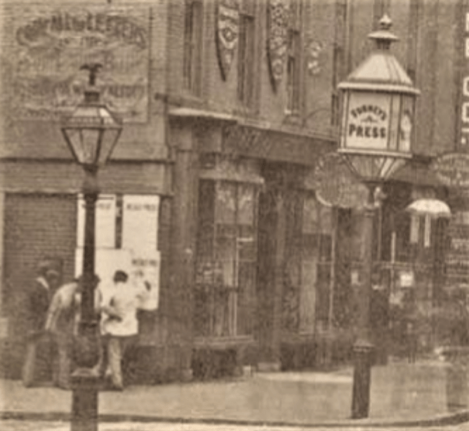
This system was taken up by the city, but coexisted with other forms, so that we read of money for “sign boards at the corners of streets and street names on lamps” (1884-85), and of expenditures for “street names upon the public lamps, sign boards, and road posts” (1887-1912). The first image in this article shows a rare corner (Walnut and Second NE, ca. 1869) where a surviving fingerpoint sign (the hand is on the right above the first “R” in Krider) coexists with Markland signs. Unlike the marble signs, the Markland name-plates seem to have been added systematically. In photographs from the decades after the patent, one can see lamps with street names at one corner after another in Center City, especially on Chestnut, and as far north as Broad and Stiles, or perhaps (in a sketch from Perspective of Philadelphia in 1886) at Columbia and Tenth; other possibilities include Butler and Second and Market and Thirty-eighth. I found about 24 clear images of street lamps with signs, with 13 images too faint for certainty. In images of the time there are many corner lamps without name-plates; perhaps the signs were concentrated in Center City.
At a favored intersection, which, or how many, corners got the signage lamps? The Markland lamps in old images are divided almost equally among the four corners. But the Library Company has two images from ca. 1868 that show Markland signs at Walnut and Fourth, on the NE and SW corners.
https://digital.librarycompany.org/islandora/object/digitool:101901

Lamps could combine multiple public functions on a sidewalk corner: illumination, signage–and a mailbox, following the 1858 patent by Albert Potts. Images of Arch and North Seventh NW (across from the site of the ruffled fingerpoints!) show the house known as Fort Rittenhouse with a plain street lamp; with businesses moved in and a Potts letter box added; with different businesses, the Potts letter box, and Markland signs; and a successor building with the signs and a round-top letter box.


Advertising on lamps (perhaps not city-owned lamps) also turns up in old images (see Chestnut and Seventh above). Advertisements were not restricted to corners, or to lamp posts, but also appeared on lamps attached to buildings. Unlike the street names on Markland’s shatterproof name-plates, the advertising was usually applied to the glass itself, but there was at least one lamp that put a business name (THE TIMES, at Chestnut and Eighth) on a metal strip.
The Markland lamps and their competitors went the way of gas lamps here and elsewhere, but in the garden of the Peale Center for Baltimore History and Architecture, and at the Baltimore Streetcar Museum, you can see a few “street names upon the public lamps.” That is not to say that they are Markland’s name strips; the street names are black on a white opaque background, the style seen in images of working street lamps in Baltimore. In Boston, a collector added, or restored, sign plates to a lamp from the intersection of Salem and Hull.
The editorialist of 1836 should have been pleased with fingerpoints, sign boards, and lamp signs. But what would the writer have made of the 1915 proposal discussed in Common Council to place “street names on telegraph, telephone, electric light, or other poles or posts”? Definitely a topic for another time.
